
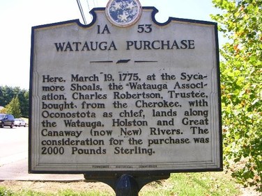
Watauga Purchase
Location:
36° 20.613′ N, 82° 15.03′ W. Marker is in Elizabethton, Tennessee, in Carter County. Marker is on West Elk Avenue (U.S. 321) west of Franklin Club Drive, on the right when traveling west. Click for map. The marker is located to the right of the main entrance to the Sycamore Shoals State Historic Area. Marker is at or near this postal address: 1651 West Elk Avenue, Elizabethton TN 37643, United States of America.
1A 53
Marker Text:
Here, March 19, 1775, at the Sycamore Shoals, the Watauga Association, Charles Robertson, Trustee, bought from the Cherokee, with Oconostota as chief, lands along the Watauga, Holston and Great Canaway (now New) Rivers. The consideration for the purchase was 2000 Pounds Sterling.
Here, March 19, 1775, at the Sycamore Shoals, the Watauga Association, Charles Robertson, Trustee, bought from the Cherokee, with Oconostota as chief, lands along the Watauga, Holston and Great Canaway (now New) Rivers. The consideration for the purchase was 2000 Pounds Sterling.
The Watauga Purchase, March 19, 1775
The Wataugans purchased the land they occupied from the Cherokee Indians in the spring of 1775 on the occasion of the Henderson purchase of Transylvania. Their purchase, as the contract below indicates, included the whole of the Watauga River valley, plus the North Carolina headwaters of the New River, plus the area below the Holston’s South Fork and below the Virginia line.
This was the boundary of “Watauga County” until 1777, when North Carolina modified its eastern boundary---cutting off the New River and edging Washington County along the UnicoiUnakas rather than the Blue Ridge divide. “This Indenture, made the 19th day of March, 1775¸ O-con-os-to-ta,Chief Warrior and First Representative of the Cherokee Nation or Tribe of Indians, and Attaculleully and Savanucah, otherwise Coronah, for themselves and the rest of the whole Nation, being the Aborigines and sole owners by occupancy from the beginning of time of the lands of the waters of Holston and Wataugah Rivers, and other lands thereunto belonging, of the one part, and Charles Robertson of the settlement of Wataugah, of the other part,
Witnesseth, &c.” The consideration was “the sum of two thousand pounds, lawful
money of Great Britain, in hand paid.” The deed embraced “ all that tract, territory, or
parcel of land, on the waters of the Wataugah,Holston and Great Canaway or New River; beginning on the south or south-west side of Holston River, Six English miles above
Long Island, in said river; thence a direct line near a south course to the ridge which
divides the waters of Wataugah from the waters of Nonachcukeh; thence along the
various courses of said ridge nearly a southeast course to the Blue Ridge or line dividing North Carolina along the Virginia line to Holston River; thence down the meanders of the Holston River to the first station, including all the waters of Wataugah¸ part of the Waters of Holston and the head-branches of New River or Great Canaway, agreeable to the bounds aforesaid, to said Charles Robertson, his heirs, and assigns,” etc.
And also the said Charles Robertson, his heirs and assigns, shall and may, peaceably and quietly, have, hold, possess and enjoy said premises, without let, trouble, hindrance or molestation, interruption and denial, of them, the said Oconostota and the rest, or any of the said Nation.”
"Signed in the Presence of
John Sevier Oconostota, his X mark. (Seal)
Wm. Bailey Smith Attacullecully, his X mark. (Seal)
Jesse Benton Tennesy Warrior, his X mark. (Seal)
Tillman Dixon Willinawaugh, his X mark. (Seal)
William Blevins
Thomas Price
Jas. Vann, Linguister.”
